


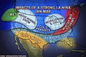
This graphic depicts average weather conditions expected across the U.S. during a strong La Niñna from January through March. In general, AccuWeather.com long range forecasters' thinking is in line with this for much of the rest of the winter.
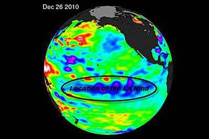
This graphic shows the area of the Pacific Ocean where the La Niña is occurring, with the large area of below-normal sea surface temperatures in blue.
2010 was a year of extreme weather events with epic flooding, snowstorms, drought, heat waves and severe cold unfolding across the U.S. and the globe. It tied 2005 as the warmest year on record, and was also a year in which one of the strongest December La Niñas in recorded history was observed.
La Niñas, which occur when sea surface temperatures across the equatorial central and eastern Pacific Ocean are below normal, play a significant role in the overall weather pattern across the globe. The current La Niña has been influential in 2010's extreme events. Details on those events and their connection to La Niña can be found in this AccuWeather.com news story.
While some of the extremes have fallen in line with overall weather conditions typically expected during a La Niña, other events have been the complete opposite. Disastrous flooding in Southern California during December and recent extreme cold, snow and ice in the Southeast are examples of events in contrast with what is typically expected during a La Niña.
So why are these extreme events non-typical for a La Niña occurring? The answer is complex and complicated. But in general, all La Niñas are different. While general trends have been observed throughout recorded history, no two La Niñas are identical.
Variations in strength of La Niñas also lend different results. In general, the stronger the La Niña (or the bigger the departure from normal in sea surface temperatures in the central and eastern Pacific), the more extreme weather events we'd expect to have. The difficult part is determining where these extreme events will occur and whether such events will occur with regularity.
Infrared satellite data, which currently is the primary means of measuring sea surface temperatures, has only been available for about 50 years. Prior to that time, most observations of sea surface temperatures came from buoys and ship reports. These older methods don't provide an adequate representation for the globe.
Therefore, there is only a short history of La Niñas and El Niños (the opposite of La Niña with warmer-than-normal sea surface temperatures in the equatorial Pacific) available for study. Thus, we're not at a point where we can directly correlate "all" extreme weather events with La Niñas or El Niños, nonetheless predict when and where they will happen.
The current La Niña is still going strong and expected to persist through at least the spring. AccuWeather.com long range forecasters think it could even last well into the summer or early fall.
So what does that mean in terms of weather for the coming months? What can people expect for the rest of winter and the upcoming spring? Will there be a continuation of non-typical extremes like we've seen over the last few months?
What to Expect in Coming Months
In short, AccuWeather.com Expert Long Range Forecaster Paul Pastelok says that we can expect to see more of the non-typical La Niñna events in parts of the country in coming weeks.
For example, he expects colder-than-normal conditions to continue affecting the East through the end of January and possibly the first half of February. In contrast to December, which was coldest compared to normal in the Southeast, the upcoming cold in the East is expected to be most extreme in the Northeast.
A blast of cold air coming to the Northeast the weekend of Jan. 22-23 is forecast to be especially brutal. A healthy snowpack covering much of the East now will help make upcoming cold outbreaks even more intense.
In the Southeast, Pastelok thinks the cold that continues in coming weeks will be significant enough to make temperatures for the entire winter average out below normal for much of the region. This would be an impressive feat, considering that La Niña winters in the Southeast are typically warmer than normal.
In general, Pastelok also expects a continuation of stormy weather from the Tennessee Valley into the mid-Atlantic for much of the rest of the season. Storms that track through this zone can vary between producing snow, ice and heavy rain.
The bitter cold destined for the East will first blast through the Midwest. So more extreme cold is in store for people across that region as well.
Southern California is still a question. Both Pastelok and AccuWeather.com Western Expert Ken Clark have commented that while a repeat of what happened in December is highly unlikely, another storm of significance cannot be ruled out for Southern California this winter.
The Southwest started this winter off with cool temperatures but has recently experienced warming. That warmth is starting to spread eastward into Texas, and Pastelok expects most of the interior Southwest and Texas to stay warmer much of the rest of the winter.
Above-normal precipitation is expected for the Northwest for the rest of the season with higher-than-normal snowfall in the interior. Temperatures should average below normal for the rest of the season.


