


France / seasonal forecasts:
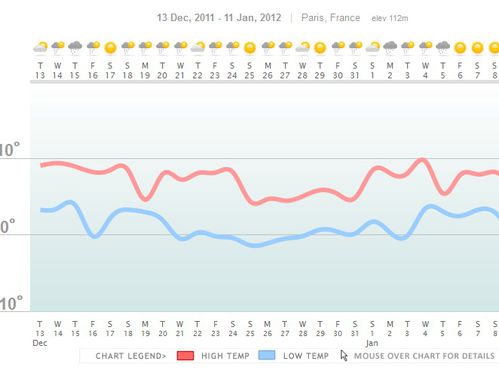
While the fall promises to be-and-already one of the sweetest of the decade, with temperatures remaining overall surplus of about 2 ° to 3 ° C in France, our seasonal forecasts considering a winter "rather in the normal," which does not exclude some cold spells.
Thus, the first - and perhaps the main - cold wave of the season should take place in France and throughout Europe in the second half of December, with temperatures at their lowest for the holidays.
The weather situation would be: the continental anticyclone should extend over the entire Western Europe, bringing a stream is dry and cold called "Moscow - Paris". This dry cold may be preceded by some snowfall in the plains, which would hold the ground because of lower temperatures, especially over eastern France. The cold snap could then continue about ten days before a slow thaw speaker for the end of December.
January could advertise again a little warmer, with temperatures remaining close to the statistical averages of reference:

click here for more information!
Long range weather forecasts : 30day View and more


